Locator Interface for Emergency (L.I.F.E.) Capstone Project Document
Introduction
In times of life or death situations and emergency problems, most people are unaware of what number to call to. But came August 1, the day the 911 was officially the national emergency hotline here in the Philippines. It was launched by the Philippine National Police (PNP) and the people or organization who are held responsible for receiving emergency calls is the 911 office located in many branches here in the Philippines then the Disaster Risk and Reduction Management Office (DRRMO) will go to the emergency situation to respond.
When the 911 began its operation in the Philippines, the police and the rescue team became very busy than the usual because of the fast response time making it effective and impressive. Though their system is effective and impressive there has no way it has no disadvantage. The disadvantage is that the emergency call can sometimes be inaccurate or choppy due to signal loss of weak signal of the phone and because of that it can most likely endanger the life of the one who needs to be rescued. Last but not the least there’s a delay in there process of emergency call, specifically here , if the emergency situation is here the emergency call will first reach the 911 office in Manila then the call will return to 911 office. That’s were our system will come in, we will help the 911 and DRRMO with their problem in terms of security, accuracy of information and direct calls.
The proponents conclude that making a system is hard and there will be many errors in the process but the hard work and sacrifices made during the process is worth it at the end of the day. Especially when the system is use to help save lives.
Background of the Study
177 was the first emergency hotline in the Philippines. It was first launched in Manila in the 1990’s. It costed them around P 1.4 billion in total. The 117 network has 16 networked call centers all over the Philippines. When President Rodrigo was elected the 117 emergency was replaced to 911 due to a vow he made during elections. On August 1, the 911 has been launched nationwide by the Philippine National Police (PNP). The 911 was patterned on the same system that was implemented in Davao by President Duterte while he was still mayor. The main issue is when the emergency call came from it will be first received at the 911 office in Manila. The receiver will ask questions and gather the data needed about the emergency situation. Then the 911 Manila office will now send the data to the 911 office. It’s time consuming and a great disadvantage to the rescuer and the people who are in need.
Statement of the Objective
With reference to the system study and the identified problems, the following are given as its objectives:
- To develop a system that can direct the information of the emergency situation to the 911 office here.
- Make a system that can locate the nearest server from your location and receive your distress signal.
- Generate a server that enable to receive the emergency signal based on their nearest client.
- To give detailed reports of the sender of their GPS coordinates, personal data, and types of emergency whether it is fire related, crime related or accident/medical related incident.
- The nearest barangay server will receive the reports and immediately respond to the accident.
Scope and Delimitation of the Study
Scope
The scope of this study is focused in making an application software that can get the current latitude and longitude or the nearest location of the user just by clicking one button and send it to the nearest server based from the sender’s current location. The user can also choose what type of emergency they are in from the application so that the server can recognize what types of emergency (e.g. fire related incident, crime related and accident/medical related incident) they have and make decision on what kind of support they can send. We also develop a server that can receive data from the client application. Calculates the nearest server from the sender and plot where the sender is located on the map.
Delimitation
This study is aimed to help the user or citizen in sending his/her emergency situation mobile application and relay the address to the nearest server location based on the sender’s current location. The address will be derived from google maps and the accuracy of the address will be based on the generated address from the reverse geocoding. Our system will solely focus on relaying and receiving data from the client to server.
Significance of the Study:
This system will be beneficial to the following identified groups:
The Filipino Citizens
This will greatly benefit the citizens of the Philippines because it will help them in case of emergency in their home, their workplace and other places.
The 911 office staff
This system will greatly help the workers of 911 because it can help provide a more accurate data and information about the reported emergency they received.
Disaster Risk and Reduction Management Office (DRRMO)
This study will greatly benefit the staff of the office because this system will make the reporting and receiving of emergency more convenient.
Researcher
This study will greatly benefit the proponents because this will broaden their knowledge in the area of emergency and rescue.
Future Researchers
This research will serve as a guide to the future researchers in creating new and more unique system.
Definition of Terms
117 – Conceptually, rescue 117 Philippines is an online and real-time blog that aims to record your help, complaints or attitudes about what happened, what happened or happened in your neighborhood (“117,” n.d.).
As used in the study, it was the previous of the current 911.
911 – Conceptually, the 911 nationwide hotline will connect the caller to emergency, rescue, police, or fire services. (“911,” n.d.).
As used in the study, it is the current emergency hotline in the Philippines nationwide.
DRRMO (Disaster Risk Reduction and Management Office). Conceptually, a government organization that’s sole purpose is to rescue and help people who are in an emergency situation. DRRMO. (“DRRMO,” n.d.).
As used in the study, it is the government sector used for responding in emergency and natural calamities or disaster.
Google Map. Is a web-based service that provides detailed information about geographical regions and sites around the world. Google Map. (“Google Map,” n.d.).
As used in the study, it is a web tool that is use to pin point where the emergency is located.
GPS (Global Positioning System). Conceptually, a navigational system using satellite signals to fix the location of a radio receiver on or above the earth’s surface. (“GPS,” n.d.).
As used in the study, it is used in locating the person who sent the emergency information.
PNP. Conceptually, the Philippine National Police (PNP) is the primary law enforcement agency of the country, which is national in scope and civilian in character. (“PNP,” n.d.).
As used in the study, government employees that responds if the emergency type is for crime related.
Reverse Geocoding. Conceptually, is a process is the process of assigning locations to addresses to that they can be placed as points on a map, similar to putting pins on a paper map, and analyzed with other spatial data. (“Reverse Geocoding,” n.d.).
As used in the study, a process of pointing a location.
System. Conceptually, a regularly interacting or interdependent group of items forming a unified whole. (“System,” n.d.).
As used in the study, organized, interrelated components that helps its users based on the purpose of the system.
Review of Related Literature
Foreign Studies:
ERS (Emergency Rescue System)
- ERS is an ICT-enabled disaster response system. It provides citizens with a single phone number to call in case of an emergency as well as graphical, real-time information for first responders. Also, it lays the foundation for an integrated disaster control system, which will strengthen national preparedness against accidents that threaten national stability and response capabilities. The system will be responsive to such threats as fire, natural disasters, and crime. The scope of the module includes developing IT service and infrastructure and detailed research activities to implement a plan for development. Different emergency responders (e.g. police, fire, hospital) must be connected into a single system that can communicate with necessary personnel and coordinate emergency response. This will require integration of systems and emergency processing method by type and area. Additionally, organizational hierarchies and protocols must be developed to establish clear lines of communication and authority in emergency situations. (“ERS,” n.d.).
Emergency+
‘Emergency +’ is a national app developed by Australia’s emergency services and their Government and industry partners, helping people to call the right number at the right time, anywhere in Australia. The app uses a mobile phone’s GPS functionality so callers can provide emergency call-takers with their location information as determined by their smart phone. It has also a direct number of Australia emergency number (000) that you can call if you have a non-emergency situation. It include SES and Police Assistance Line numbers as options. It has a different button for different scenario so the user can identify on what kind of problem they have and the receiver can deploy the right kind of help to the sender. (“Emergency +,” n.d.).
Call Ambulance – Emergency App
- CallAmbulance is a platform where emergency providers have to be on a network. Currently CallAmbulance is focused on Hyderabad, India. Call Ambulance prepares you to respond to an emergency situation by simplifying the process of calling an ambulance, Unlike a regular call for an ambulance service, we are working with various hospitals to prepare them with your health records and insurance details prior to arriving at your location. It has many functions:
- Get your location in the hands of emergency provider such as GVK EMRI so that Ambulance Manager, Driver knows your location and reach you as fast as possible.
- Get your Doctor at destination hospital know your health condition and health history so that they are better prepared even before you arrive at the hospital
- We are actively training/building a First Responder Network so that someone who has a bit of training in CPR, Trauma can step up and help the citizen in distress before the Ambulance arrives
- (“Call Ambulance,” n.d.)
Local Studies:
Pure Force Citizens
- Pure Force Citizens APP is a private initiative to offer to the public and government agencies a single tool to reach for help in emergency situations. Pure Force and Rescue Corporation is a technology and innovative leader, specializing in security and rescue throughout the whole Philippines. We aim to connect security organizations and emergency response teams, thereby minimizing response times and maximizing situational awareness. Through our strategic partnership with a credible and renowned global technology provider, Pure Force aims to be the leading provider of specialized security and rescue solutions in the Philippines.
- (“Pure Force,” n.d.)
911 Philippines
- 911 Philippines is a free software application from the System Maintenance subcategory, part of the System Utilities category.
Directly call Philippines 911 and 8888 emergency service. You can also ask a load from your prefer network to be able to call 911, 8888 or text, or call other people during emergency.
It is a mobile app that allow you to instantly call the emergency number that is listed in the application by just clicking a button. It is a practical app that can save your life in case of emergency. Even you don’t have a mobile load it will automatically borrow load from your network provider so that you can call 911 for help.
- (“911 Philippines,” n.d.)
Philippines Emergency Hotline (PLEH)
- PLEH or try to read it backward, is a mobile application for Android and iOS devices. The Philippines emergency numbers and help hotlines compiled into one website and mobile application to facilitate faster contact with the right government bureaus in certain issues of every concerned individual online or offline.
- It has a complete and updated directory of all Philippines Government agency. Subscribers will receive notifications of the most recent and news updates, circular, important information’s and events within the archipelago.
- Next update PLEH will be an apt way to store information such as personal and medical profiles like name, birthdate, blood types, allergens and other health information that may be needed by the rescuers and doctors once a victim or need emergency assistance.
- (“PLEH,” n.d.)
Related Systems
Synthesis
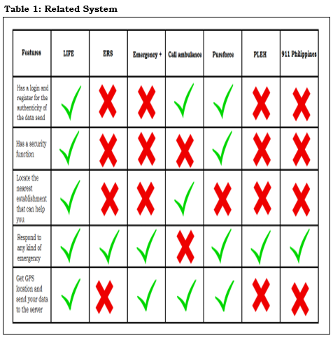
The proponents search the web about many application that is related or similar to our system and we choose 3 foreign system and 3 local system to make a comparison to our system. Every system that they found on the web is very unique and has a bit similarities with the proponents but there are still big difference. Like the Emergency+, CallAmbulance and PureForce, both there system and our system use GPS coordinate to determine the position of the sender and what types of emergency they have. The ERS, PLEH, and 911 Philippines use the call function of the mobile phone to report their emergency to the rescuer. Using GPS and call function have good side and downside like using a call function is much delayed because the sender must first identify their location and the nearest landmark on them and report it to the rescuer. While it’s good side is the accuracy of the reported incident and the data that can give by the sender.
And the downside of GPS function is the accuracy of the receive data because it use google maps and it rely on the accuracy of the google map to pinpoint the latitude and longitude of the sender. While its good side is its simplicity in sending the emergency signal, all it takes is one click away.
Methodology
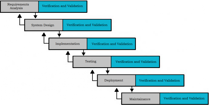
Making this system is very arduous work because our team only have one year worth of time to finish this project. In just one year worth of time we need to study about Java, Ajax, jQuery, JavaScript and google maps API. In our first three months (October – December) we plan and analyze on what programming language we will use in our client system and what kind of software application we must use in developing our system, we try many language and application to develop our client like restful API and B4A. From January to February we make the design of our android application and our admin page, we also try to analyze on what is the needed program to run google maps API on our website, their also a big change on our system happened in this phase so we returned to our analyzing phase and analyze the changes we must do to finish our system. The next three months (March – May) our team make a big step in implementing our system, our programmer develop the system and implement it. And in testing phase we detect many error in our design and implementation so we go back to our development phase and our designing phase. After we make sure that our system has no more bugs and error we will proceed to deployment phase and maintenance phase.
Planning Phase
The project started with finding a company that would accept the proponents offer for system study of the development. Then the proponents will conduct an interview and survey to the company whom accepted the offer.
Analysis Phase
In this phase the proponents will conduct a meeting and create possible solutions out of the gathered data from the company. Then the proponents will have a title proposal after that. It will be approved by the capstone adviser. After that the proponents will create the system.
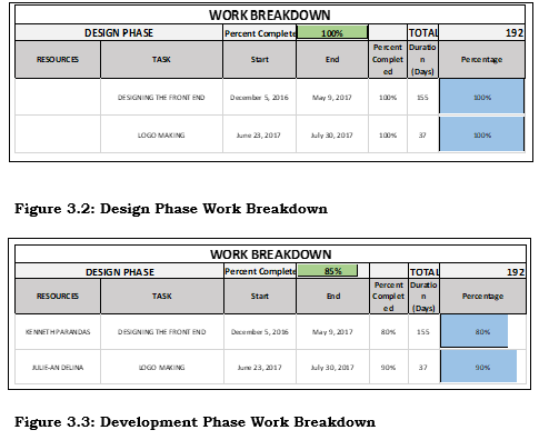
Design Phase
In this phase the proponents will start designing the front end and the logo of the system.
Development Phase
In this phase the proponents will now begin the coding and developing of the front end and back end of the system.
Testing Phase
After developing the system the proponents will now test the system if it has errors. First the Alpha testing which will be conducted by the proponents then after that the Beta test will start. Beta testing in which chosen users will use the system for it to gain reviews and responses.
After the Alpha and Beta testing the proponents will conduct a survey to the company and the users of the system.
Implementation Phase
This phase will be for the implementation of the system or when will this be released. After the system would be functional and tested and proven, that will be the time for the system to be released. The approximate date will be on 2018.
Maintenance Phase
The system requires maintenance and support. The comments and suggestions made by the customers and administration are essential in enhancing the system. For this purpose, the maintenance of the system is scheduled every 3 month in order to maintain the system’s functionality.
System Development Life Cycle
Modified Waterfall Method
We user waterfall as our model because it is much better than the regular waterfall method which is a non-iterative design process, it means that once you make a mistake you cannot go back to your previous phase unless you restart your system. As a student it is easy for us to make a mistake or do some experiment in our system like trial and error. So the modified waterfall is the exact SDLC for us, because once you make a mistake you can still review your past phase and check whether you make a mistake or error and fix it.
Like in our system we made a countless of error in our system analysis and when we proceed to design we discover that we made a mistake in analysis phase, also in our design phase there is a big change in our system that is recommended by panelist, so we go back to our analysis phase and analyze our next steps to make to finish this system. When we are in testing phase our programmer make a big error in developing our system development, so the programmer go back the implementation and design phase to determine the error and fix it. At the time we reach the deployment phase, if we still make an error we can still easily go back to the previous phase and modify the error and code the system again.
USER ACCEPTANCE SURVEY
The system will underwent testing and will be approved by the chosen users who will use it as well as the company.
REQUIREMENT SPECIFICATIONS
Operational Feasibility
The Locator Interface for Emergency (LIFE) can help the 911 in emergency situations by receiving emergency messages and gather the data of the person who used the application.
Program Environment
Front End
HTML5, is a markup language used for structuring and presenting content on the World Wide Web. It is the fifth and current version of the HTML standard. It was published in October 2014 by the World Wide Web Consortium (W3C).
HTML5 includes detailed processing models to encourage more interoperable implementations; it extends, improves and rationalizes the markup available for documents, and introduces markup and application programming interfaces (APIs) for complex web applications.
Google Maps, is a web mapping service developed by Google. It offers satellite imagery, street maps, 360° panoramic views of streets (Street View), real-time traffic conditions (Google Traffic), and route planning for traveling by foot, car, bicycle, or public transportation.
Xml, XML is a file extension for an Extensible Markup Language (XML) file format used to create common information formats and share both the format and the data on the World Wide Web, intranets, and elsewhere using standard ASCII text.
XML is similar to HTML. Both XML and HTML contain markup symbols to describe the contents of a page or file. HTML, however, describes the content of a Web page (mainly text and graphic images) only in terms of how it is to be displayed and interacted with.
Back End
PHP, is a widely-used open source general-purpose scripting language that is especially suited for web development and can be embedded into HTML.
Javascript, often abbreviated as JS, is a high-level, dynamic, weakly typed, object-based, multi-paradigm, and interpreted client-side programming language. Alongside HTML and CSS, JavaScript is one of the three core technologies of World Wide Web content production. It is used to make webpages interactive and provide online programs, including video games.
Java, is a general-purpose computer programming language that is concurrent, class-based, object-oriented and specifically designed to have as few implementation dependencies as possible. It is intended to let application developers “write once, run anywhere” (WORA), meaning that compiled Java code can run on all platforms that support Java without the need for recompilation.
AJAX, is a set of Web development techniques using many Web technologies on the client side to create asynchronous Web applications.
Mysql, is an open source relational database management system (RDBMS) based on Structured Query Language (SQL).
MySQL runs on virtually all platforms, including Linux, UNIX, and Windows. Although it can be used in a wide range of applications, MySQL is most often associated with web-based applications and online publishing and is an important component of an open source enterprise stack called LAMP.
Technical Feasibility
- Hardware
- Hard disk: 500 GB
- RAM: 2 GB
- Processor: pentium
- Motherboard: ASUS 1150M Motherboard
- Monitor: Resolution 720px
- Mouse: USB Type
- Keyboard: USB type
- Smart phone
- 512mb ram
- 10mb memory
- Software
- Android application
- XAMPP
- Web browser
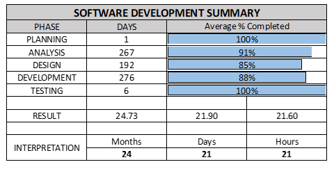
Feasibility Schedule
The feasibility schedule contains the amount of time the proponents spend in developing the system.
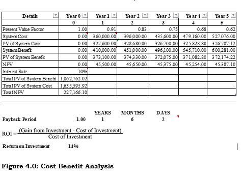
Cost Benefit Analysis
Cost Benefit Analysis or CBA estimates the total of all expenses from the development of the system to the operational cost and it’s benefits to the company.
Development Cost
The table shows the developmental cost of the system. The development cost consists of programmer’s fee, system analyst’s fee and internet fee and the total cost in developing the system. (“Job Street,” n.d).
| Development Cost | Duration | Monthly Cost | Total Amount |
| Programmer | 12 months | 15,000,00 | 180,000.00 |
| System Analyst | 12 months | 10,000.00 | 120,000.00 |
| Internet Fee | 12 months | 2,000.00 | 24,000.00 |
| Total | 12 months | 27,000.00 | 324,000.00 |
Table 2.0: Development Cost
Operational Cost
This table shows the operational cost of the system. The operational cost covers the electricity bill and the internet fee. (“PLDT,” n.d), (“CENECO,” n.d).
| Operational Cost | Duration | Monthly Cost | Total Amount |
| Electricity Bill | 12 months | 1,000.00 | 12,000.00 |
| Internet Fee | 12 months | 2,000.00 | 24,000.00 |
| Total | 12 months | 3,000.00 | 36,000.00 |
Table 2.1: Operational Cost
Total Cost
The table shows the developmental and operational cost of the system.
| Developmental Cost | 324,000.00 |
| Operational Cost | 36,000.00 |
| Total | 360,000.00 |
Table 2.3: Total Cost
Benefit
The Benefit table shows the probable amount that the company might achieve if the system would be implemented.
| Benefit of the System | |
| Labor Efficiency | 50,000.00 |
| System Cost | 360,000.00 |
| Total | 410,000.00 |
Table 2.4: Benefit
Presentation, Analysis and Interpretation of Data
This chapter exhibits the results of the User’s Survey conducted for the system.
Presentation
The proponents selected the staff of the DRRMO and the 911 as respondents of their system’s testing and demonstrate to them the functionality of the system. The respondents on were evaluated using the User Acceptance Survey in order for the respondents to distinguish the level of acceptability of the proposed system.
Data Analysis
This section presents the analysis of the data collected and gathered from the respondents of Locator Interface for Emergency (L.I.F.E.).
Characteristics of the Respondents
The population was composed of the staff of the DRRMO and the 911. The proponents got thirty (30) respondents from the staff.
Respondents
| Respondents Frequency | |
| DRRMO Staff | 15 |
| 911 Staff | 15 |
| TOTAL | 30 |
Frequency of Respondents
This table shows the frequency of respondents who answered the User-Acceptability Survey. The proponents got a total of 30 respondents.
Reliability Testing
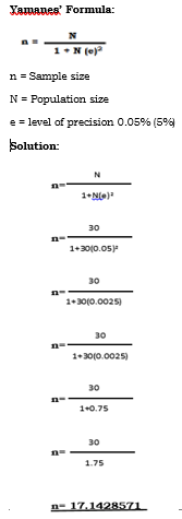
The data collected by the proponents have undertaken reliability testing. An acceptable approach through using the Yamanes Formula in order to identify the sample size of population that will undergo the user acceptance survey.
This solution explains the summation of getting the sample size (n) of the population that will be taking the user acceptance survey. Where n=30 divided by 1+30 multiplied by 0.75 as (e) or the level of precision. As the proponents gets the (e), it is divided to 30 as the total population size (N). The result was 17.1428571 for the sample size of the population (n).
Interpretation of Data
The proponents used an observation that evaluates the awareness of the user in terms of 5 categories: Effectiveness, Efficiency, Quality, Timeliness and Productivity. Every category has a rating scale of 1 to 5 with 1 as very dissatisfied, 2 as dissatisfied, 3 as neutral, 4 as satisfied and 5 as very satisfied.
| Range of Mean Verbal Interpretation | |
| 4.21 – 5.00 | Very Satisfied |
| 3.41 – 4.20 | Satisfied |
| 2.61 – 3.40 | Neutral |
| 1.81 – 2.60 | Dissatisfied |
| 1.00 – 1.80 | Very dissatisfied |
Table 2.0: Rating Scale
This table shows the range of means and its verbal interpretation.
Respondents Survey
This shows the result of user acceptance survey in which so respondents were tested, where every category were computed. Each of the computed averages was presented through tables below to precisely showcase each categories mean.
| Effectiveness | |||||||
| Question 1 | Question 2 | Question 3 | Question 4 | Total | |||
| Mean |
|
3.7 | 3.8 | 3.4 | 3.775 | ||
Survey Result – Effectiveness
This table shows that the user survey result for the effectiveness of the system came back with a total mean of 3.775 interpreted that the client were satisfied with the system’s completeness and accuracy of the system, report generation, search, retrieval and dissemination of required information and report generation flexibility after testing it.
| Efficiency | |||||||
| Question 1 | Question 2 | Question 3 | Total | ||||
| Mean |
|
4.4 | 4 | 4.2 | |||
Survey Result – Efficiency
This table shows that the user survey result for the efficiency of the system came back with a total mean of 4.2 which reads that the client were satisfied with the system’s ease of use, complexity of the task and task accuracy after testing it.
| Quality | |||||
| Question 1 | Question 2 | Question 3 | Question 4 | Total | |
| Mean | 4 | 4.3 | 4.3 | 4.3 | 4.225 |
Survey Result – Quality
This table shows that the user survey result for the quality of the system came back with a total mean of 4.225 which reads that the client were satisfied with the system’s report content, report flexibility, report turnaround time and report consistency after testing it.
| Timeliness | |||||
| Question 1 | Question 2 | Question 3 | Question 4 | Total | |
| Mean | 3.9 | 4 | 3.5 | 4.1 | 3.875 |
Survey Result – Timeliness
This table shows that the user survey result for the timeliness of the system came back with a total mean of 3.875 which reads that the client were satisfied with the system’s system accessibility, system adaptability, data security and achievement of goals after testing it.
| Productivity | |||||
| Question 1 | Question 2 | Question 3 | Question 4 | Total | |
| Mean | 4.4 | 4.5 | 4.3 | 4.3 | 4.375 |
Survey Result – Productivity
This table shows that the user result for the productivity of the system came back with a total mean of 4.375 which reads that the client were satisfied with the user assistance, throughout and decision support after testing it.
Based on the previous tables from the survey result in 5 categories the proponents conclude that is rated as 4.09 interpreted as satisfied.
Summary of Findings, Conclusion and Recommendation
This chapter presents the summary or the research work undertaken, the conclusion drawn and the recommendation made as an outgrowth of this study.
Summary of Findings:
The proponents conducted an interview to the DRRMO, a government office and the proponents identified that one of their office has a lack of knowing if there is an emergency in their area. So the proponents decided to make a system that can solve their dilemma and make their job in monitoring as convenient as possible, yet the data they receive are accurate as possible.
The proponents make a proposal to make a system that can help both the proponents and the office and present it to the title hearing. Even the system propose has many defect, the panel still approve the system. In the mock defense the panel see many problem to the propose system and decided to improve the system by adding a function that can determine the nearest server to the sender for the betterment of the system.
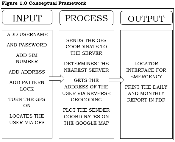
Locator Interface for Emergency is a system that can receive a data from its client (Android mobile app) to its server (web server). The data it receive is the sender GPS coordinates and it determine the nearest server to sender based on its GPS coordinates. LIFE system focus on getting the sender data and location, it also plot the sender location on the web server map and reverse geocode the latitude and longitude to get the address of the sender.
The proponents conducted a user’s acceptance survey to the office of 911 and DRRMO to evaluate the acceptability of the client to the system if it could get a good average rate in system effectiveness, efficiency, quality, timeliness, and productivity. The result of the survey satisfy both the proponents and the client which the system get an astonishing result of 4.375 interpreted as satisfied. It can be seen on Chapter 4 above.
Conclusion
The proponents of the system must have a knowledge on their system and enough skills to achieve the completion of the proposed system. The proponents must have team coordination in order to fulfill what they wanted. The proponents also conclude that the LIFE system is much useful to the DRRMO regarding to their works.
Recommendation:
The proponents recommend that the 911 office must have the following:
- The 911 office must have a pc unit that is connected to internet.
- The administrator must have basic knowledge on php, MySQL, java, and JavaScript.
- The 911 office must have a steady fast connection of internet.




Leave A Comment
You must be logged in to post a comment.